I was recently asked by the owners of Quarry Farm, Bodiam, to look at the Roman roadside settlement on their land, which is right up my (Roman) street. They were kind enough to put me up in their fantastic glamping site, with views across the settlement to the castle :

View to the castle from the glamping hut
The site was excavated back in the 1960's, when the Battle and District Historical Society dug up a Roman building with Classis Britannica stamped tiles associated with it. The Roman road broadly follows the modern road across the floodplain, and the presence of the CL:BR stamped tiles in the floodplain has led to the interpretation of the site as a port. Further to the south, as the land rises out of the floodplain, some iron slag has been found, suggesting an iron working site.
Lidar shows up an interesting feature in the floodplain, an embanked paleochannel that cuts much further south than the current course of the river. It has been suggested that the river was redirected further north in medieval times to help fill the moat. Also look at the two fields just south of the floodplain, and notice that the field on the left is significantly higher than the field on the right.
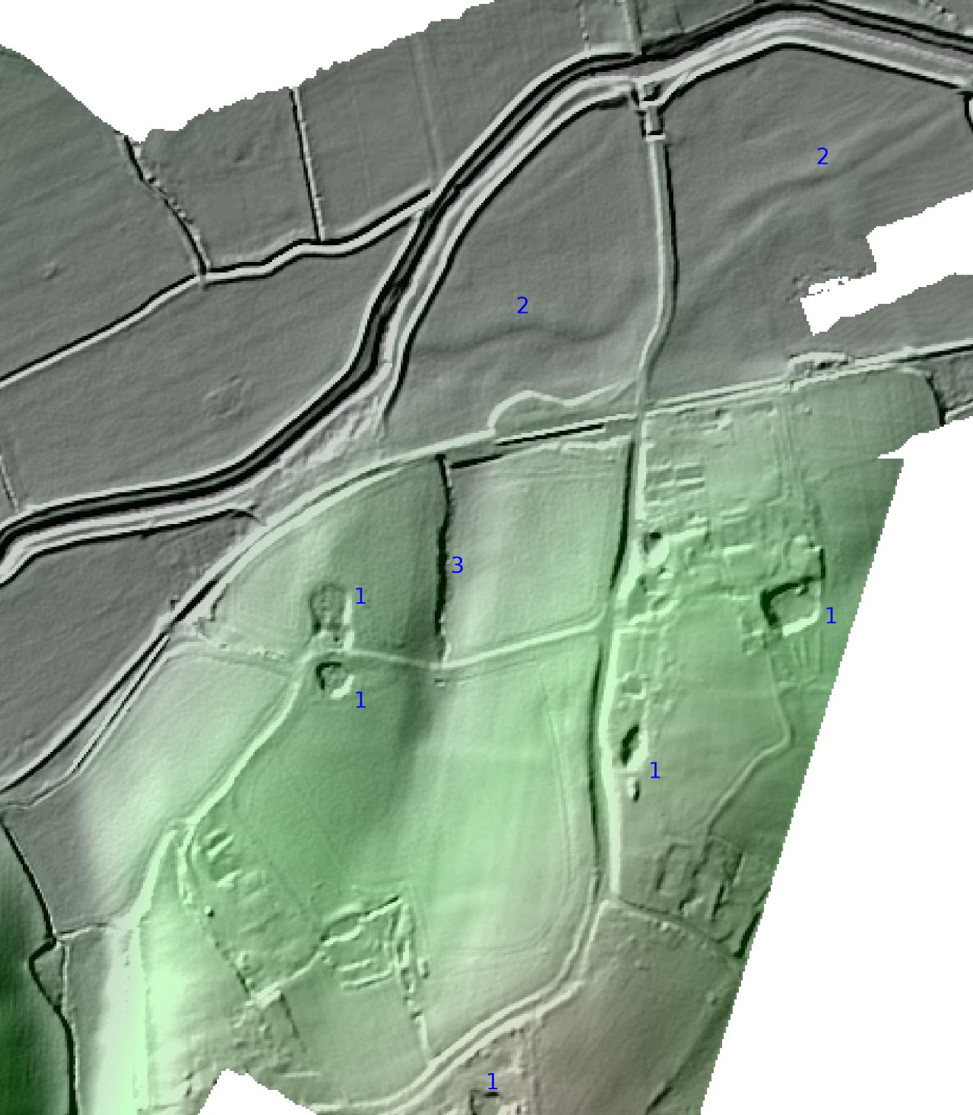
lidar of the site, click for larger image
So what about the geophysics? Starting with magnetometry, the reason for the height difference between the two fields is obvious, as there is a medium sized iron working site, whose slag heap has raised the level of that field compared to the one next door. You can also see a slag metalled track leading from the Roman road (to the east) to the iron working site. The floodplain is not so easy to interpret. There is a lot of metal junk, geological features, and material from the railway and modern road. It's difficult to say with certainty from the magnetometry that anything in there is Roman, despite the amount of Roman material found in excavation.

Magnetometry, click for larger image
It's down to the radar to help sort the mess out. The orange lines mark out the areas surveyed with GPR. The black rectangle is the Battle and District Historical Society excavation area, in which was found the building they excavated. That building doesn't show up on the radar, which is not surprising, as the excavations were described as waterlogged, and GPR doesn't do well with wet alluvium. There is what looks like new building just next to it though, closer to the road. Most interesting though is an oval bowl shaped feature surround on three sides by hard standing. My gut says this is an upstream port, but the paleochannel seems to go through it rather than by the side of it, so I'm not sure what to make of it.

Interpretation of floodplain GPR, click for larger image
Back at the iron-working site, the radar showed the extent of the slag heap as an amplitude change on the enveloped data, and also showed the location of three bloomeries as circular phase change features on the unenveloped data.

Interpretation of iron working GPR, click for larger image
So there's a lot going on, but not quite as large a settlement as expected. If you want to know more, you can read the full report here.